Route 66 isn’t the road it once was.
It has been eclipsed as a cross-country thruway by a series of interstates, the main one Interstate-40, which was built directly over Route 66 much of the way and shares more than 1,300 miles of generalized route with the historic route.
The 1,200 miles left of the nearly 2,500-mile old Route 66 has been swept up in other roadways from state highways to city streets.
But Route 66 isn’t entirely gone.
It might be a little bit of a ghost, but it still rolls across the American Mid- and Southwest, in and out of towns and cities, through vast stretches of barren desert.
Today, we call it by multiple other names, but, for the most part, you can still drive the old route.
And, when you do, you’ll be rolling over a true piece of American history, the road that carried young adventure-seekers west and that farmers traveled to escape the Dust Bowl of the 1930s.
You’ll also pass through eight different U.S. states, each with their own distinctive segments of road to offer along the way.
The states through which Route 66 passes are (from east to west):
- Illinois
- Missouri
- Kansas
- Oklahoma
- Texas
- New Mexico
- Arizona
- California
And the best way to see the segments of Route 66 left behind in these eight states?
Get in your car and just start driving.
Route 66 Through Illinois
The original Route 66 started in Chicago in the northeast corner of Illinois, crossing the state like a sash from the shoulder on the banks of Lake Michigan to the waist in the southwestern edge.
The largest portion of Route 66 in Illinois has been swept up into Interstate-55.
When you drive I-55 from Chicago to St. Louis, Missouri, you are mostly driving along the old route.
But a few detours along the way will really give you that Route 66 feel.
Route 66 National Register Stretches in Illinois
Multiple portions of Route 66, not just through Illinois, but in many of the states Route 66 passes through, have been listed on the National Register of Historic Places.
In Illinois, the portions of Route 66 on the National Register are:
Historic Route 66 between Cayuga and Chenoa

Route 66 by Carpenter Park (Southbound) in North Springfield

Historic Route 66 North of Litchfield to Northwest of Mount Olive

Frontage Road from Possum Hill Road in Worden to the northeast corner of Hamel

State Route 4 and Snell Road North of Auburn (Illinois Brick Road)

IL State Route 4 between Girard and Nilwood

Of these historic segments, Snell Road North of Auburn may be the most “must-see.”
On this segment, you will drive over the last remaining hand-laid brick road in Illinois, a 1.4-mile stretch that was part of the original Route 66.
Other Important Segments of Route 66 Through Illinois
Though it’s not on the National Historic Register, one last segment of Route 66 you might want to drive in your quest to follow the old route through Illinois is I-55’s frontage road.
Route 66 Along I-55 Frontage Road
Northeast of Gardner is where this long stretch of Historic Route 66 begins.
It starts on the northbound side of I-55, parallel to IL-53, and serves as a frontage road for most its route, switching sides of the interstate several times.
Along the way, the road skirts many towns, passing through Bloomington (as Veterans Parkway/US-55/Hamilton Road), and runs all the way down to Williamsville (northeast of Springfield).
The National Register section of Cayuga to Chenoa is part of this section of road.
This Frontage Road swath of Route 66 is the most complete length of Historic Route 66 you can follow through Illinois.
Frontage Road Gardner to Bloomington

Frontage Road Bloomington to Williamsville

Note: You have to do a little wrapping around in Bloomington to get back on Route 66, as the old sections of Route 66 meet at an overpass.
Route 66 Through Missouri
Route 66 enters Missouri through the heart of St. Louis, heading southwest toward the bottom western corner of the state to meet the Kansas border at Joplin.
As in Illinois, the rough outline of Route 66’s route was redirected to the interstate, with I-44 following the same general path of the original road.
But that doesn’t mean when you drive I-44 from St. Louis to Springfield, you are following the old Route 66.
Instead, most segments of Route 66 in Missouri remain, branching and curving away from the interstate in sweeping segments.
Route 66 Scenic Byways in Missouri
No individual sections of Route 66 through Missouri are on the National Register of Historic Places.
Instead, Missouri has designated the original roads that made up Route 66 as scenic byways, and you can follow them through every Missouri county Route 66 passes through from St. Louis County in the east to Jasper County in the west.
Maps of Route 66 through each county are available through the Missouri Department of Transportation.
Though, they are listed in alphabetical instead of directional order, which isn’t ideal.
So, for the record, here is the county order from east to west:
- St. Louis
- Franklin
- Crawford
- Phelps
- Pulaski
- Laclede
- Webster
- Greene
- Lawrence
- Jasper
And from west to east:
- Jasper
- Lawrence
- Greene
- Webster
- Laclede
- Pulaski
- Phelps
- Crawford
- Franklin
- St. Louis
If you drive the roads on the Missouri Department of Transportation maps, you will cover the entirety of Historic Route 66 through Missouri.
Route 66 Through Kansas
Unliked the other states Route 66 passes through, Route 66 barely blips through Kansas, boxing in its southeastern corner between the Missouri state line at Galena and the Oklahoma state line at Baxter Springs.
All in, only 11 miles of Route 66 passes through the state.
Route 66 National Register Stretches in Kansas
Just because there are only 11 miles to choose from, however, doesn’t mean some of Route 66 through Kansas hasn’t landed on the National Register of Historic Places.
The section of road granted that honor is:
West 7th Street between the Missouri state line and Eastern Galena (All 1.2 miles of it!)

Driving Route 66 in Kansas
Short though it may be, the path of Route 66 through Kansas is still intact and can be driven in its entirety.
To drive the original route, enter Galena on 7th Street and follow it until it turns into U.S. Route 66.
Turn right when you hit Beasley Road and take the first left.
You are now following the old Route 66 over the original Rainbow Bridge.
Take a left when the road dead-ends (you’ll be back on Beasley Road) and turn right to get back on Route 66.
Continue on the road into Baxter Springs.
You’ll dead-end into Military Avenue/ALT US-69.
Then, take a right and follow ALT US-69 to the Oklahoma state line.
And, bam, just like that, you’ve driven all of Route 66 through Kansas.
Route 66 Through Oklahoma
As sparse as Route 66 is in Kansas, it’s back to passing through entire states once it reaches Oklahoma.
In fact, Route 66 passes right through the heart of Oklahoma, entering it at its northeastern corner and evening out toward the western edge of the state.
It’s in Oklahoma City, right where the lush east meets the arid west, that Route 66 stops moving in a southwesternly direction and becomes a mostly westward route.
As in most states, the old route has been swept up in Oklahoma’s interstate system, running alongside, and occasionally even being absorbed by, segments of I-35, I-44 and I-40 along the way.
Still, the original path of Route 66 through Oklahoma is largely intact, with Western Oklahoma being where Route 66 really starts to come into its historic past.
Route 66 National Register Stretches in Oklahoma
Several sections of Route 66 through Oklahoma are on the National Register of Historic Places.
The portions of Route 66 in Oklahoma listed on the National Register are:
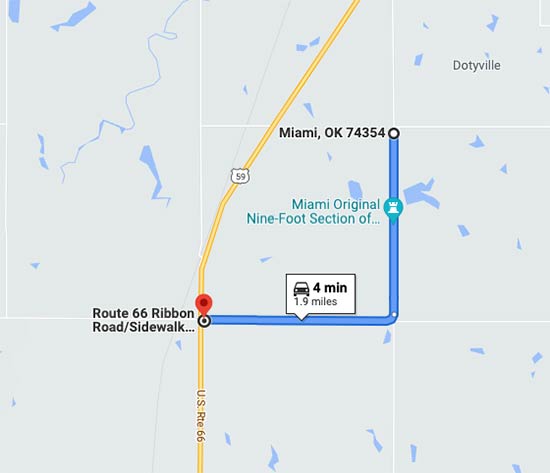
Nine-Foot “Ribbon Road” Section of Route 66 (S 540 Rd south of E 130 Rd and continuing west on E 140 Rd) in Miami

Junction of Route 66/Ozark Trail and OK-66 in Sapulpa

Junction of Route 66 and OK-66 in Bristow

U.S. Route 66 East of Milfay Road in Depew (0.46 miles)

Old Hwy 66 SSE from the junction of OK-66 and Hiwassee Rd. (splits off from U.S. Route 66 and loops back onto it)

What makes the “Ribbon Road” segment of Route 66 in Miami a standout is that it’s only nine-feet in width.
It’s the only remaining nine-foot section of the original Route 66 that remains.
In Sapulpa, you’ll see the remnants of an abandoned segment of Route 66 at the junction of Ozark Trail and OK-66.
If you take Ozark Trail, you’ll cross the Rock Creek Bridge, a steel-truss bridge with a hand-laid brick roadway.
In Bristow, the junction of Route 66 and OK-66 is really nothing special.
But if you head north on Bristow’s Main Street, you’ll be driving the historic route through town, which has loads of that “old road” feel.
Other Important Segments of Route 66 Through Oklahoma
While the path of Route 66 has largely been swept up into Oklahoma’s interstate system, many of the original roads on Route 66 also still remain.
The original path mostly follows ALT US-69 out of Baxter Springs, Kansas, US-69, US-59, US-60, OK-66, US-40/I-40.
Along the way, Route 66 joins other roads and separates again multiple times, but can be followed mostly in its entirety across the state.
Route 66 Through Texas
Though Route 66 passes all the way through Texas, it does so at the panhandle, running alongside (or directly on) I-40, giving this huge state the second lowest number of miles of the road after Kansas.
But that doesn’t mean Route 66 through Texas doesn’t have a lot to offer your Route 66 road trip.
The Texas towns I-40 passes through have retained the old Route 66 as a business loop (in some places it’s been incorporated into US-40).
When you drive these bypasses, you will still see the essence of the old road still very much intact.
Route 66 National Register Stretches in Texas
Three segments of Route 66 through Texas are on the National Register of Historic Places.
The portions of Route 66 in Texas listed on the National Register are:
Frontage Road (south side) in Wheeler County between the Oklahoma state line and Gray County (ending approx. 5 miles east of McLean)

U.S. Route 66 between TX-207 and I-40 (Conway/Panhandle)

6th Avenue between S Georgia St and S Forest St in Amarillo (original alignment)

Other Important Segments of Route 66 Through Texas
The business loops/US-40 through multiple towns in Texas run along the original Route 66 and keep much of the nostalgia of the era alive.
Towns where you will absolutely want to pop off the interstate and pass through from east to west are:
- Shamrock (US-40)
- McLean (US-40/First St)
- Conway/Panhandle (U.S. Route 66)
- Amarillo (US-40/Amarillo Blvd/6th Ave)
- Vega (US-40/Main St)
- Adrian (US-40)
- Glenrio (US-40)
Note: The National Register historic segment through Wheeler County includes the business loop through Shamrock.
The 6th Avenue area of Amarillo is perhaps the most historically significant segment of Route 66 left in Texas, while, in Adrian, you’ll pass the midway point of the original route.
And if you’re looking for signs of where life used to be, but no longer exists, Glenrio is a ghost town in the truest sense of the word.
Route 66 Through New Mexico
As in Texas before it and Arizona to come, Route 66 through New Mexico largely follows the path of I-40.
Or, rather, I-40 followed the path of Route 66. But that was a later alignment.
When Route 66 first routed through the state, it swung up to pass near Las Vegas, NM, through Santa Fe, and down into Los Lunas.
You can still follow both these routes across the state.
Route 66 National Register Stretches in New Mexico
Most New Mexico segments of Route 66 that are on the National Register of Historic Places are listed simply because they are state-maintained.
These segments of road offer little of historic value (much of Route 66 in New Mexico is state-maintained), so we’re leaving them off our list.
There are, however, three portions of Route 66 in New Mexico listed on the National Register that are not simply state-maintained.
These segments are:
US. Route 66 from the Texas border to San Jon (locally-maintained)

Cross Road (Abandoned Route 66) from Cuervo to NM-156

NM-124 between the New Laguna I-40 exit and McCarty’s

Other Important Segments of Route 66 Through New Mexico
One portion of Route 66 through New Mexico that is not on the National Register of Historic Places, but has loads of historic value is Central Avenue through Albuquerque.
Route 66 Along Central Avenue Albuquerque
When Route 66 was first routed, Central Avenue was the original path through Albuquerque, and you can still follow that path all the way through the city.

As for the best route to travel Route 66 through New Mexico, the New Mexico Tourism Department provides a map with both the original alignment (inc. Santa Fe and Los Lunas) and the realignment (the straighter path along I-40).
You can find it here: New Mexico Route 66 National Scenic Byway
Route 66 Through Arizona
Just as it does through the Texas panhandle and New Mexico, the path of Route 66 through Arizona runs in a fairly straight (east-west) line across the state.
Laying out the eventual route for I-40, much of Route 66 through Arizona has been repurposed into the interstate itself.
There are, however, a few notable exceptions.
Route 66 National Register Stretches in Arizona
There are several segments of Route 66 through Arizona on the National Register of Historic Places.
The portions of Route 66 in Arizona listed on the National Register are:
Rural Route 66 at Brannigan Park, East Parks

Abandoned Route 66 in East Parks

Rural Route 66 West Parks to Beacon Hill

Abandoned Route 66 between Williams and Ash Fork (West of Delta Tank)

Bill Williams Ave between Pine and 6th Streets in Williams

The two segments of abandoned Route 66 in East Parks and West of Delta Tank can no longer be driven, but can be traversed on foot.
In Parks, Abandoned Route 66 runs just north of the paved Route 66 that remains.
Coming from the east, Rural Route 66 touches this abandoned section, making it easy to locate.
Note: Most of the abandoned and rural segments of Route 66 in the Williams/Parks area are roads through Coconino National Forest.
Other Important Segments of Route 66 Through Arizona
Along with its National Register entries, Arizona has some very fine non-registered traces of Route 66 within its borders.
Some are famous, some are off the beaten path, and some take a little bit of courage to drive.
I-40 Through Winslow

Here, you’ll drive right over one of the coolest Route 66 crests in any of the eight states Route 66 passes through.
It adorns the intersection right by Standin’ on the Corner Park, a public park that commemorates the famous line from the Eagles’ hit song “Take It Easy.”
Townsend-Winona Road between the I-40 Winona exit (Exit 211) and Highway 89

Historic Route 66/US-40 in Flagstaff

Today, US-40 through Flagstaff follows the original route of Route 66.
You can switch to the original road (from I-40) well east of the city (Exit 204) and follow it all the way across the city until it dead-ends back into I-40.
AZ-66 Coconino-Yavapai County Line to Kingman

Original Route 66 departs from the interstate west of Ash Fork (Exit 139) and curves up into Peach Springs before crossing I-40 south of Kingman and turning into Oatman Highway.
Oatman Highway
As far as the thrill of the old Route 66, you can’t do better than Oatman Highway.
This steep, narrow two-lane road will give you a feel for what it was really like to drive Route 66 in its heyday, before roads were built for 55 mph+ speed limits.
It’s nearly 50 miles of uninterrupted Route 66 running from south of Kingman through the mountainous terrain of western Arizona to kiss the eastern bank of the Colorado River and California state line.
Basically, it’s a beauty.

Oatman Highway is also a dangerous road with sharp turns, steep drop-offs, and nonexistent guardrails.
It’s not for the faint of heart or nervous drivers, but, in our opinion, it may be the coolest section left of the original Mother Road.
Route 66 Through California
California is where Route 66 takes its final bow (when you’re rolling from east to west).
You might enter the state on I-40, but you won’t stay on it for long.
Much of the original Route 66 is still around, curving north and south, east and west, departing from the interstate every chance it gets.
In the Inland Empire and Los Angeles, Route 66 has faded into city streets, going strictly urban in San Bernardino and passing through Rancho Cucamonga and the L.A. suburbs of Duarte, Monrovia, and Pasadena.
While there isn’t much left of Historic Route 66 once you reach its westernmost miles, you can still see traces of the old road from the shadows of the San Bernardino Mountains to the streets of Hollywood.
Route 66 National Register Stretches in California
No sections of Route 66 through California are on the National Register of Historic Places. (A group of Californians are currently in the process of registering multiples structures and locations associated with Route 66.)
There are, however, two National Scenic Byway sections of Route 66 through California and they are:
Historic Route 66 between Needles and Barstow

Arroyo Seco Parkway (CA-110) between Pasadena and Los Angeles

Important Segments of Route 66 Through California
Just because there’s not much registered in California doesn’t mean there’re aren’t plenty of important segments of Route 66 left to drive in the state.
These sections of road retain considerable historical value and will give you the feel of rolling down the Mother Road back in the day.
Route 66 Through Needles

National Trails Highway East of Fenner to Ludlow
Along this section of road, you’ll pass a set of abandoned towns.
While most of what was there is now gone, you can see the remnants of the living, breathing stops they must once have been.
(This section is part of the National Register historic route between Needles and Barstow.)
Main Street Barstow

Part of Route 66 east of Barstow now lies inside a military base.
You cannot drive this section of road, and must pop back onto the Interstate to bypass it.
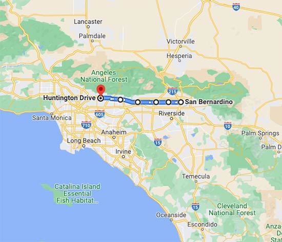
5th Street/Foothill Boulevard/Huntington Drive/Colorado Place/Colorado Blvd/Arroyo Seco Pkwy/Sunset Blvd/Santa Monica Blvd (San Bernardino to Santa Monica)
- San Bernardino to Arcadia:

- Arcadia to Santa Monica:

This segment of Route 66 has largely been swallowed up by the sprawling metro areas of Los Angeles and the Inland Empire.
It’s been said it’s so urban and new, you can’t even tell the old road was once there.
But that’s really a matter of perspective.
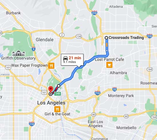
While it’s fair to say most of the old road has been swallowed up by L.A’s bustling ecosystem, you can still see patches of it in historic buildings and on the roads themselves.
Many roads from San Bernardino and Pasadena have been designated with road signs marking them as part of the original Route 66.
Route 66 signed roads in San Bernardino and Los Angeles counties are:
- Foothill Boulevard from San Bernardino through San Dimas
- Huntington Drive in Arcadia
- Colorado Boulevard in Pasadena
Basically, if you follow Route 66 from San Bernardino to Pasadena, you will see plenty of signs marking the history along the way.
Route 66 in Los Angeles County
Due to sheer population, the roads that make up historic Route 66 in Los Angeles County are the most driven sections of the old road.
These roads have also lost a lot of their Route 66 charm, though, so are some of the least driven by those following historic Route 66 cross-country.
While the signs of the old road may start to lessen the further west in California you go, though, they are still there.
You just have to open your eyes and really look.
A lot of people on Route 66 road trips will skip this section.
That’s why you shouldn’t.
